Evaluating Mangrove Conservation Effectiveness in Peam Krasop Wildlife Sanctuary, southwest Cambodia
The study compared mangrove cover and fragmentation pattern change between Peam Krasop Wildlife Sanctuary (PKWS), southwest Cambodia and the surrounding non-protected area between 2014 and 2020 to investigate the conservation effectiveness of PKWS.
Explore the Spatial Pattern of Dengue Fever in Pennathur, Southern India
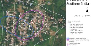
Dengue Fever is a potentially fatal illness that is spread by mosquitoes. The spatial statistics tools in ArcGIS was used to better understand the spatial pattern of Dengue Fever in Pennathur, a village in Southern India.
Using Random Forest to predict the presence and absence of a Cactus species
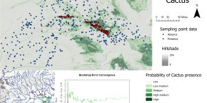
In this lab, we used machine learning in R to classify the presence and absence of a Cactus species. In addition, a probability surface was created to show where this species is expected to appear.
Explore different methods of spatial interpolation to make DEM
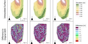
Three different interpolation methods were used to predict elevations based on sample points. The interpolated DEM from these points was compared to a LiDAR-derived DEM.
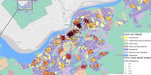
Study the relationship between alcohol and violent crime
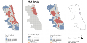
Studies have demonstrated a link between alcohol and violent crime. More specifically, neighborhoods with more alcohol sales such as having more liquor stores or restaurants that sale alcohol may experience more frequent incidences of violent crimes. As a result, government agencies are considering limiting access to alcohol in neighborhoods with high crime density by reducing the number of liquor stores and rejecting new liquor license requests.
Lights on and lights out - stay tuned

The map showed where nightlights have turned on and dropped off between 2012 and 2016. Nightlights provide an interesting way to study human activities and spread globally.
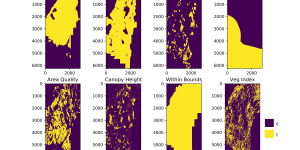
Using suitability/capability modeling to identify critical habitats
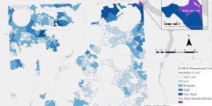
The study aimed to find suitable habitats for a hypothetical genetic engineered species l.millipedis using suitability and capability modeling.
Digitizing Koh Rong National Marine Park, Cambodia in Google Earth Pro
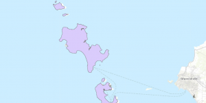
Established in 2018, the Koh Rong National Marine Park is the first marine national park in Cambodia. However, no boundary shapefile can be found online yet, so I digitized it and uploaded the shapefile online.
Using Avenza Maps to collect GPS data
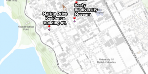
Avenza Maps can be used on mobile devices to capture GPS data. In this lab, I collected GPS locations for Placemarks on UBC campus and recorded a walk. Then I uploaded the data to Google Earth Pro and ArcGIS as KML file for further analysis.
Map of Critical Habitat for Marbled Murrelet using QGIS
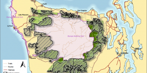
QGIS is a popular open-source GIS software with advanced capabilities. The QGIS GUI is especially helpful for interactive data analysis, such as data display, digitization, or map generation. In this lab, I made a map of critical habitat for Marbled Murrelet using QGIS.
Develop total aboveground biomass (AGB) and dominant tree height model using LiDAR data
Up-to-date forest inventories are essential for achieving sustainable forest management by providing information on forest structural attributes, species composition, and health status. The traditional method to produce forest inventories by conducting field work can be time consuming and costly. The development of LiDAR technique can support the need by characterizing forest attributes in an accurate and cost effective manner.
NDVI time series analysis in R
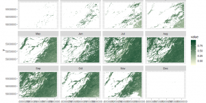
The normalized difference vegetation index (NDVI) data from 2007 to 2017 for a study area in Alberta was derived from the MODIS Terra product MOD13Q1. A time series analysis was performed to study the change of NDVI across years.
Using Python to identify a maple farm location
An area in Malcom Knapp Research Forest that can fit a specific set of environmental criteria was selected to grow a specific maple tree species.
Crime analysis in Ottawa using CrimeStat
The spatial distribution of crimes in Ottawa occurred between January 2005 and March 2006 was studied using CrimeStat.
Using Geographically Weighted Regression (GWR) to explore the relationship between child’s language skills and variables associated with the neighborhood and child’s characteristics
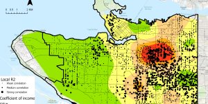
Language skills of a child can be associated with a set of variables related to the neighborhood or the child’s characteristics such as social skills and physical abilities. Both GWR and GLR were performed and compared to study the relationships and predict child’s language skills across Vancouver.
Land Use Changes Driven by Urbanization in Edmonton, Canada between 1966 and 1976
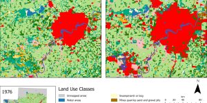
Urbanization is a global phenomenon leading to increasing concerns about land use change and growing pressure on surrounding ecosystems. Edmonton, AB, Canada has undergone significant changes in land use from 1966 to 1976 due to rapid expansion of urban built-up.
Hot Spot Analysis of Heart Disease Mortality by County in Southern United States, 2016
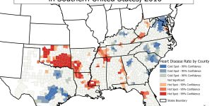
This map is a hot spot analysis of heart disease mortality by county in the southern United States in the year 2016. The mortality and population counts by county for all age and gender groups were obtained from CDC Wonder Database.