Skip to content

Zuofang Zhang

ePortfolio

Menu
  • About
  • Activities
  • Skills
    • ArcGIS Pro
    • ArcGIS Online
    • Statistical Analysis
    • ArcMap
    • Web AppBuilder
    • R
    • ENVI
    • QGIS
    • Avenza Maps
    • Python
    • FRAGSTATS
    • FUSION
    • CrimeStat
    • Field Skill
  • Experience
    • Cartography
    • Spatial autocorrelation analysis
    • Land cover/use classification
    • Landscape fragmentation analysis
    • Capability and suitability model
    • Geospatial data analysis in R
    • Land cover change detection
    • Crime analysis
    • Hot spot analysis
    • Digitizing and georeferencing
    • Estimate forest attributes and develop statistical models from LiDAR metrics
    • Time series analysis in R
    • Health geography
    • Interpolation
    • ModelBuilder in ArcGIS

Skill: CrimeStat

Spatial analysis of crime data

Crime analysis in Ottawa using CrimeStat

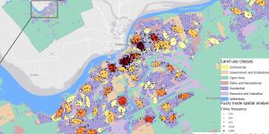
The spatial distribution of crimes in Ottawa occurred between January 2005 and March 2006 was studied using CrimeStat.


Brought to you and supported by UBC Arts ISIT


TERMS OF SERVICE