Skip to content

Zuofang Zhang

ePortfolio

Menu
  • About
  • Activities
  • Skills
    • ArcGIS Pro
    • ArcGIS Online
    • Statistical Analysis
    • ArcMap
    • Web AppBuilder
    • R
    • ENVI
    • QGIS
    • Avenza Maps
    • Python
    • FRAGSTATS
    • FUSION
    • CrimeStat
    • Field Skill
  • Experience
    • Cartography
    • Spatial autocorrelation analysis
    • Land cover/use classification
    • Landscape fragmentation analysis
    • Capability and suitability model
    • Geospatial data analysis in R
    • Land cover change detection
    • Crime analysis
    • Hot spot analysis
    • Digitizing and georeferencing
    • Estimate forest attributes and develop statistical models from LiDAR metrics
    • Time series analysis in R
    • Health geography
    • Interpolation
    • ModelBuilder in ArcGIS

Experience: Spatial autocorrelation analysis

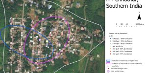
Explore the Spatial Pattern of Dengue Fever in Pennathur, Southern India

Dengue Fever is a potentially fatal illness that is spread by mosquitoes. The spatial statistics tools in ArcGIS was used to better understand the spatial pattern of Dengue Fever in Pennathur, a village in Southern India.


Crime analysis in Ottawa using CrimeStat

The spatial distribution of crimes in Ottawa occurred between January 2005 and March 2006 was studied using CrimeStat.


Using Geographically Weighted Regression (GWR) to explore the relationship between child’s language skills and variables associated with the neighborhood and child’s characteristics

Language skills of a child can be associated with a set of variables related to the neighborhood or the child’s characteristics such as social skills and physical abilities. Both GWR and GLR were performed and compared to study the relationships and predict child’s language skills across Vancouver.


Brought to you and supported by UBC Arts ISIT


TERMS OF SERVICE