Skip to content

Zuofang Zhang

ePortfolio

Menu
  • About
  • Activities
  • Skills
    • ArcGIS Pro
    • ArcGIS Online
    • Statistical Analysis
    • ArcMap
    • Web AppBuilder
    • R
    • ENVI
    • QGIS
    • Avenza Maps
    • Python
    • FRAGSTATS
    • FUSION
    • CrimeStat
    • Field Skill
  • Experience
    • Cartography
    • Spatial autocorrelation analysis
    • Land cover/use classification
    • Landscape fragmentation analysis
    • Capability and suitability model
    • Geospatial data analysis in R
    • Land cover change detection
    • Crime analysis
    • Hot spot analysis
    • Digitizing and georeferencing
    • Estimate forest attributes and develop statistical models from LiDAR metrics
    • Time series analysis in R
    • Health geography
    • Interpolation
    • ModelBuilder in ArcGIS

Experience: Land cover/use classification

Evaluating Mangrove Conservation Effectiveness in Peam Krasop Wildlife Sanctuary, southwest Cambodia

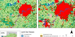
The study compared mangrove cover and fragmentation pattern change between Peam Krasop Wildlife Sanctuary (PKWS), southwest Cambodia and the surrounding non-protected area between 2014 and 2020 to investigate the conservation effectiveness of PKWS.


Land Use Changes Driven by Urbanization in Edmonton, Canada between 1966 and 1976

Urbanization is a global phenomenon leading to increasing concerns about land use change and growing pressure on surrounding ecosystems. Edmonton, AB, Canada has undergone significant changes in land use from 1966 to 1976 due to rapid expansion of urban built-up.


Brought to you and supported by UBC Arts ISIT


TERMS OF SERVICE