Skip to content

Zuofang Zhang

ePortfolio

Menu
  • About
  • Activities
  • Skills
    • ArcGIS Pro
    • ArcGIS Online
    • Statistical Analysis
    • ArcMap
    • Web AppBuilder
    • R
    • ENVI
    • QGIS
    • Avenza Maps
    • Python
    • FRAGSTATS
    • FUSION
    • CrimeStat
    • Field Skill
  • Experience
    • Cartography
    • Spatial autocorrelation analysis
    • Land cover/use classification
    • Landscape fragmentation analysis
    • Capability and suitability model
    • Geospatial data analysis in R
    • Land cover change detection
    • Crime analysis
    • Hot spot analysis
    • Digitizing and georeferencing
    • Estimate forest attributes and develop statistical models from LiDAR metrics
    • Time series analysis in R
    • Health geography
    • Interpolation
    • ModelBuilder in ArcGIS

Experience: Interpolation

Explore different methods of spatial interpolation to make DEM

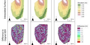
Three different interpolation methods were used to predict elevations based on sample points. The interpolated DEM from these points was compared to a LiDAR-derived DEM.


Brought to you and supported by UBC Arts ISIT


TERMS OF SERVICE