A set of 1182 points that represent a ground survey at Malcolm Knapp Research Forest (MKRF) was used to determined the elevation of each point on the landscape. Three different methods were used to create an interpolated DEM from these points including Kriging, IDW, and Spline.
IDW: IDW function uses the average values of sample points in the neighborhood to make predictions (Esri, n.d.). This interpolation method assumes that the local influence or weight of a sample point decreases with distance. In other words, the further the distance, the fewer impacts a data point has on predicting the values of neighboring points. IDW function performs better when sampling is dense enough to capture the variations in the landscape. However, because the prediction is a weighted distance average of the neighborhood, it cannot be larger or smaller than the highs or lows which may not be able to capture extremes.
Kriging: Kriging function uses semivariogram to take into account spatial autocorrelation when making predictions (Esri, n.d.). Similar to IDW, Kriging function weights the values of surrounding sample points by distance. However, Kriging also uses semivariogram to describe the relationship between distance and variance between sample points and unknown points. As a result, predictions made by Kriging depend on both distance and the spatial arrangement.
Spline: The predicted surface of Spline passes through all sample points (Esri, n.d.). Spline function tends to reduce the overall surface curvature and smooth the surface. Additionally, Spline function can make predictions that are larger or smaller than the largest or smallest sampling values.
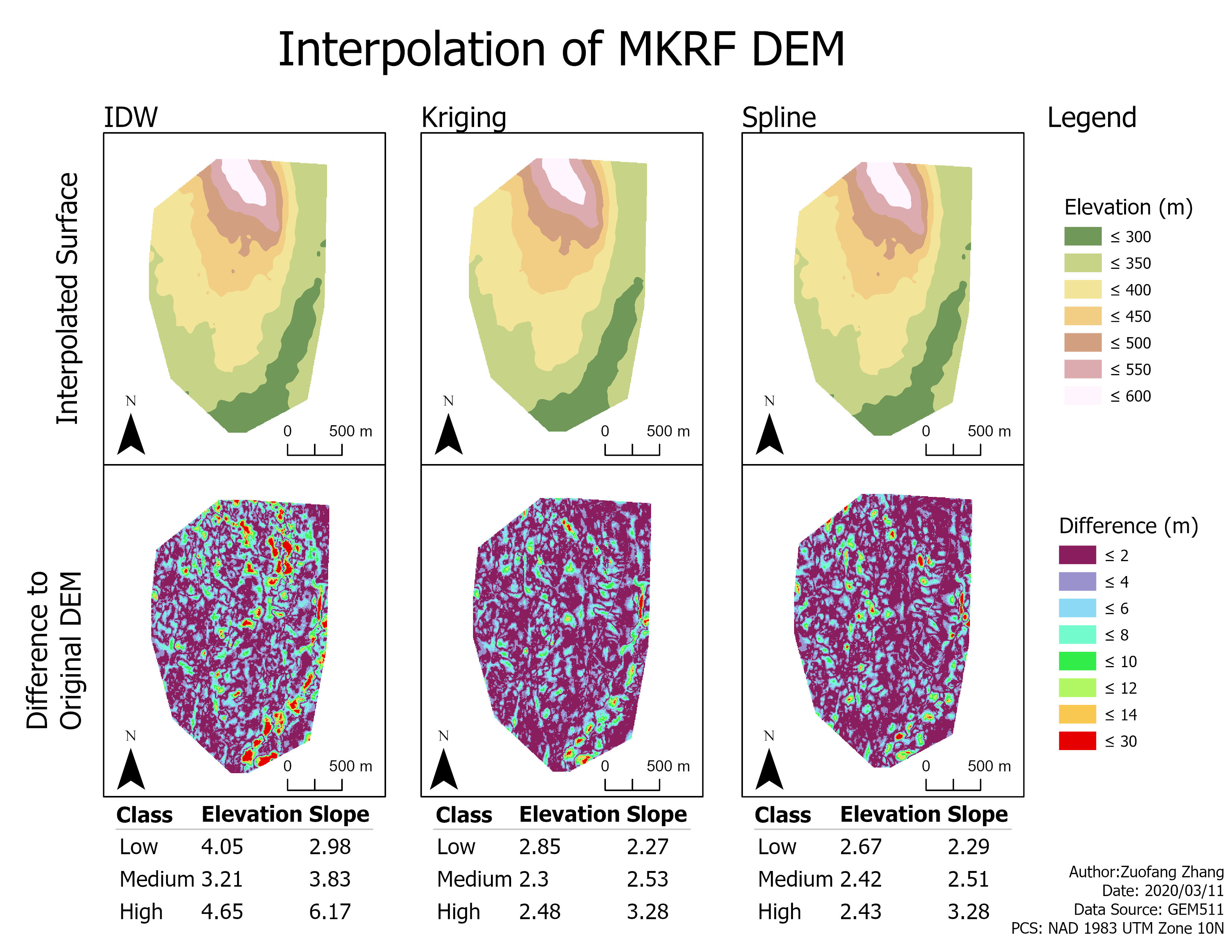
Spline and Kriging have similar performance. Generally, Spline has smaller differences for both elevation and slope when their classes are high and low. However, Kriging has smaller difference for elevation of middle class. To sum up, Spline performed the best overall.
Generally, the medium class of elevation has the smallest difference compared to the corresponding low and high classes for all of the three interpolation methods. However, the increase in slope leads to a decrease in the accuracy of the interpolated surface. The trend is the most obvious for differences between the interpolated surface made by IDW and the LiDAR-derived surface. This may due to the working principle of IDW. IDW cannot make predictions that are smaller or larger than the smallest and largest sampling values, thus, it may not be able to capture extreme values leading to less accurate interpolated surface at low and/or high elevation and/or slope.
Reference
Esri (n.d.). Comparing interpolation methods. Retrieved on March 22 from https://pro.arcgis.com/en/pro-app/tool-reference/3d-analyst/comparing-interpolation-methods.htm