Skip to content

Zuofang Zhang

ePortfolio

Menu
  • About
  • Activities
  • Skills
    • ArcGIS Pro
    • ArcGIS Online
    • Statistical Analysis
    • ArcMap
    • Web AppBuilder
    • R
    • ENVI
    • QGIS
    • Avenza Maps
    • Python
    • FRAGSTATS
    • FUSION
    • CrimeStat
    • Field Skill
  • Experience
    • Cartography
    • Spatial autocorrelation analysis
    • Land cover/use classification
    • Landscape fragmentation analysis
    • Capability and suitability model
    • Geospatial data analysis in R
    • Land cover change detection
    • Crime analysis
    • Hot spot analysis
    • Digitizing and georeferencing
    • Estimate forest attributes and develop statistical models from LiDAR metrics
    • Time series analysis in R
    • Health geography
    • Interpolation
    • ModelBuilder in ArcGIS

Zuofang Zhang

Hello and Welcome!

I am an early career GIS professional specialized in environmental and natural resources management.
I am passionate about GIS, cartography, and data visualization. Here you can learn more about what I have done using GIS and remote sensing techniques.

About Me

Browse My

Featured Learning Activities

Evaluating Mangrove Conservation Effectiveness in Peam Krasop Wildlife Sanctuary, southwest Cambodia

The study compared mangrove cover and fragmentation pattern change between Peam Krasop Wildlife Sanctuary (PKWS), southwest Cambodia and the surrounding non-protected area between 2014 and 2020 to investigate the conservation effectiveness of PKWS.

NDVI time series analysis in R

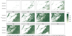
The normalized difference vegetation index (NDVI) data from 2007 to 2017 for a study area in Alberta was derived from the MODIS Terra product MOD13Q1. A time series analysis was performed to study the change of NDVI across years.

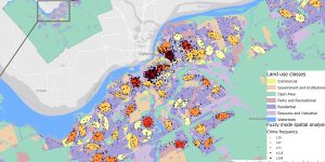
Crime analysis in Ottawa using CrimeStat

The spatial distribution of crimes in Ottawa occurred between January 2005 and March 2006 was studied using CrimeStat.

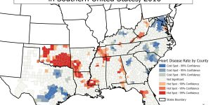
Hot Spot Analysis of Heart Disease Mortality by County in Southern United States, 2016

This map is a hot spot analysis of heart disease mortality by county in the southern United States in the year 2016. The mortality and population counts by county for all age and gender groups were obtained from CDC Wonder Database.

Browse My

Skills

View More

ArcGIS Online

Cloud-based GIS mapping

ArcGIS Pro

Explore, visualize, and analyze geospatial data

ArcMap

Explore, visualize, and analyze geospatial data

Avenza Maps

Collect GPS location data using mobile devices

CrimeStat

Spatial analysis of crime data

ENVI

Geospatial image analysis

Field Skill

Collect soil and plant sample, identify coastal BC plant, operate GPS equipment, and measure forest attributes

FRAGSTATS

Calculate landscape metrics for categorical map patterns

FUSION

View and analyze LiDAR data

Python

Python programming language

QGIS

Open-source GIS mapping

R

R programming language for statistical computing and graphics

Statistical Analysis

Linear regression models and spatial statistics

Web AppBuilder

Build web apps to visualize geospatial data

Browse My

Experience

View More

Capability and suitability model

Cartography

Crime analysis

Digitizing and georeferencing

Estimate forest attributes and develop statistical models from LiDAR metrics

Geospatial data analysis in R

Health geography

Hot spot analysis

Interpolation

Land cover change detection

Land cover/use classification

Landscape fragmentation analysis

ModelBuilder in ArcGIS

Spatial autocorrelation analysis

Time series analysis in R

Brought to you and supported by UBC Arts ISIT


TERMS OF SERVICE